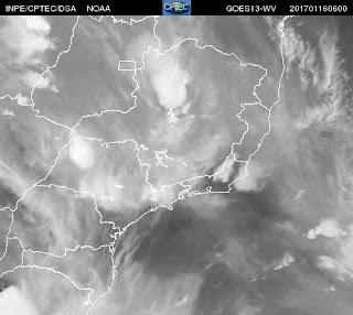
On the 17th, a Humidity Convergence Zone (ZCOU) was configured between Mato Grosso and São Paulo, that later in the week evolved to a South Atlantic Convergence Zone (ZCAS), leading to high levels of accumulated rain and floods (news here, here, here and here).
The convective systems formed on the 15th and 16th of January were selected as a case study, while the ZCOU/ZCAS formation and extended precipitation during the following week were selected as another case study. However, images in this entry correspond only the first tree days of the period.
For January 15, 2017, NASA released an image comparing GOES-16 and GOES-13 , corresponding to 6:07 PM (GMT). The GOES-16 was created using several of the 16 spectral channels available on the ABI sensor. In this image, numerous small convective systems can be seen over São Paulo state .
Source: GOES-16 Image Gallery
Storms were reported in other regions as well, as Indaiatuba and the Paraíba Valley.
 |
| Storm in Indaiatuba on January 16th. |
Lightning strike as detected by Brasildat network within a 180 km radius centered in Campinas can be seen below for January 15th:
The following images show the CAPPI 3km from Radar São Roque for January 15th (source CPTEC).
The following images show the VIL values for January 15th.
The following images show the EchoTop 20dBz values for January 15th.
Satellite images from GOES-13 (source CPTEC) for January 15th can be seen below:
GOES visible channel images:
GOES IR channel (highlighted) :
GOES WV channel:
Images for the 16th and the 17th can be found in the second and third part of this post, respectively.


No comments:
Post a Comment